
The state of polar sea ice in April 2010 is fairly good compared to climatological conditions (1979-2000), which strongly contrasts with the past few months when global conditions were below climatology. As it has done this time of year for a few years in a row, the global sea ice extent increased to the point where it is near climatological values, as this graph demonstrates. The anomalies observed in 2006 and 2007 become more obvious each time the globe’s sea ice increases in March/April.
Arctic Ice
The state of Arctic sea ice in April 2010 grew slightly worse from March’s near-average conditions. Bering Sea ice extent remained above-average, while the extent in the Barents Sea and Baffin Bay was below average. The areal extent of Arctic sea ice remained just below average conditions for most of the month until weather patterns shifted in the last week and a dramatic melt began. The rapid decrease in extent and openings in the middle of the ice pack point toward the lack of multi-season ice and the prevalence of single-season ice, which melts faster than older ice. As the melt season continues, weather patterns and the lack of multi-season ice will have big effects on the export of ice into the Atlantic Ocean and the rate at which that ice melts.
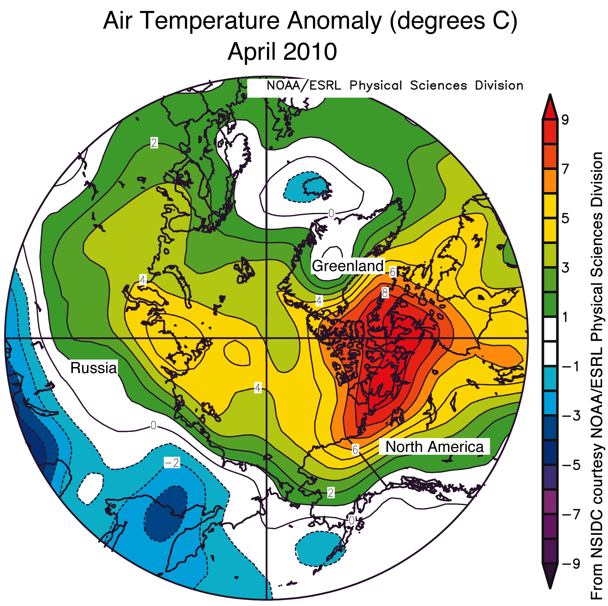
The Arctic Oscillation that sent so much cold air to the south this winter, and was more strongly negative than any time in the past 50 years, became less intense – to the point that it was characterized as ‘neutral’ heading into May. The near-surface temperatures in the Arctic region remained above normal (+2 to 3C in most locations, +7 to 9C in the northern Canadian Arctic!!) throughout the month again. A side note here – above normal temperatures doesn’t mean above freezing. Abnormally warm conditions in the winter and spring are still below and near freezing.
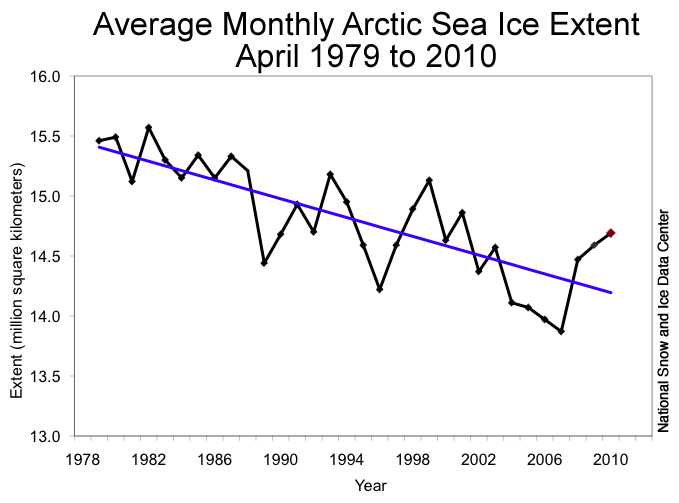
The average ice extent for April 2010 was 14.69 million sq. km., which was larger than during any April in the past 9 years. That extent was 820,000 sq. km. more than the record low extent set in 2007. Since 1978, the Arctic sea ice extent in April has decreased at 2.6% per decade.
Antarctic Ice
The state of Antarctic sea ice in April 2010 was better than it was during March 2010 – nearly matching the average extent relative to climatological norms. The areal extent shifted from below normal to slightly more than normal during the month. The yearly minimum was reached in early February, and the ice has been steadily growing ever since.
#####
Here are my State of Polar Ice posts from April and March.
Pictures and Graphs
Here is a satellite representation of Arctic sea ice conditions from May 4th:

For comparison purposes, here is the similar picture from April:

Here is the time series graph of Arctic sea ice extent with the +/- 2 standard deviations as a light-gray envelope around the climatological average through yesterday:

You can find the NSIDC’s April report here. The page is dynamic, so if you’re reading this after May 2010, that month’s report will show up first. If that’s the case, you can look for the April report on the top pull-down tab on the right-hand side of the page.
Here is a satellite representation of Antarctic sea ice conditions from yesterday:

For comparison purposes, here is the similar picture from April:

Here is the time series graph of Antarctic sea ice extent with the +/- 2 standard deviations through yesterday:

Cross-posted at SquareState.

Pingback: State of the Poles – 6/21/10 « Weatherdem’s Weblog
Pingback: State of the Poles – 7/7/10 « Weatherdem’s Weblog